Subcatchment Data Fields (SWMM)
Subcatchment data can be edited on either the Subcatchment Grid Window of the Subcatchments Grid or the Subcatchment Property Sheet.
Most data can be edited on the grid, but some fields cannot be displayed in the grid format.
To view and edit all subcatchment data, use the Property Sheet.
The following describes all the data which can be used to define a subcatchment. For details of results fields, see the Subcatchment Results Data Fields (SWMM) topic.
 Common Data Fields
 Fields that are common to the majority of objects can be found in the Common Fields topic.
Subcatchment Data
Database Table Name: sw_subcatchment
|
Field Name |
Help Text |
Database Field |
Size |
Precision |
Default |
Error Lower Limit |
Error Upper Limit |
Warning Lower Limit |
Warning Upper Limit |
||||||||||||||||||||||||||||||||||||||||||
|---|---|---|---|---|---|---|---|---|---|---|---|---|---|---|---|---|---|---|---|---|---|---|---|---|---|---|---|---|---|---|---|---|---|---|---|---|---|---|---|---|---|---|---|---|---|---|---|---|---|---|---|
|
Subcatchment ID |
A unique name for the subcatchment. |
subcatchment_id |
Text |
254 |
|
0 |
|
|
|
|
|
||||||||||||||||||||||||||||||||||||||||
| Rain gage ID | The name or identifier of the Rain Gage associated with this subcatchment. | raingauge_id | Text | 254 | |||||||||||||||||||||||||||||||||||||||||||||||
| Drains to |
The type of object to which this subcatchment drains. The choices are:
|
sw_drains_to | Text | 20 | sw_node | ||||||||||||||||||||||||||||||||||||||||||||||
|
The name of the node or subcatchment to which this subcatchment drains. The name can be either be typed in or selected from a dropdown. The list is automatically populated when an option is selected in the Drains to field. |
outlet_id |
Text |
254 |
|
0 |
|
|
|
|
|
|||||||||||||||||||||||||||||||||||||||||
|
Area |
Area of the subcatchment. The default area is calculated from the subcatchment's geometry. |
area |
Double |
|
CA |
3 |
|
0 |
|
|
|
||||||||||||||||||||||||||||||||||||||||
|
x |
The X co-ordinate at the centre of the subcatchment boundary region. If the system default flag (#D) is set, the X co-ordinate at the centroid of the subcatchment will be determined by ICM. |
x |
Double |
|
XY |
1 |
|
|
|
|
|
||||||||||||||||||||||||||||||||||||||||
|
y |
The Y co-ordinate for the centre of the subcatchment boundary region. If the system default flag (#D) is set, the X co-ordinate at the centroid of the subcatchment will be determined by ICM. |
y |
Double |
|
XY |
1 |
|
|
|
|
|
||||||||||||||||||||||||||||||||||||||||
| Width |
The width of the overland flow path for sheet flow runoff. |
width | Double | L | 0 | ||||||||||||||||||||||||||||||||||||||||||||||
|
Slope |
The average gradient at which the subcatchment drains to the node. |
catchment_slope |
Double |
|
S |
3 |
0.005 |
|
|
|
|
||||||||||||||||||||||||||||||||||||||||
| Imperviousness | The percentage of the subcatchment's land area (excluding the area used for LID controls) which is impervious. | percent_impervious | Double | 3 | 0.01 | 0 | 100 | ||||||||||||||||||||||||||||||||||||||||||||
| Use area-averaged rain |
Applicable when using spatial rainfall (from Events or TSDB). Check this option to calculate rainfall for the subcatchment as the area-average of the rainfall of all rainfall polygons or radar cells that overlap the subcatchment. Any areal reduction/calibration factors set for the rainfall polygons are incorporated in the calculation of the area-averaged rainfall. A rainfall profile is created for each subcatchment which is then passed to the simulation engine. If this option is not checked, the rainfall polygon or radar cell that contains the centroid of the subcatchment will be used to provide rainfall data for the entire subcatchment. The rainfall rate for every radar cell is sent to the simulation engine as a separate rainfall profile, and the engine checks the centroids to determine which profile to use. See Spatially Varying Rainfall in SWMM Networks and Using Spatial Rainfall in SWMM Simulations for further details. 
Note
The simulation engine can process up to 2,147,483,647 TSDB generated rainfall profiles in a single simulation. Therefore if radar images with more cells than this are imported, spatial rain zones must be used to crop them to less than 2,147,483,647 cells for any given simulation (and similarly for subcatchment-averaged rainfall, where per-subcatchment profiles also need to be taken into account). |
area_average_rain | Boolean | 0 | |||||||||||||||||||||||||||||||||||||||||||||||
| Runoff model type |
Specifies which model is to be used to simulate runoff for this subcatchment. The choices are:
See Subcatchments for details. |
runoff_model_type | Text | 16 | 0 | SWMM | |||||||||||||||||||||||||||||||||||||||||||||
| Impervious roughness |
Displayed when Runoff model type is set to SWMM. The value of Manning's n for overland flow over the impervious portion of the subcatchment. |
roughness_impervious | Double | 8 | 0.01 | 0 | 0 | ||||||||||||||||||||||||||||||||||||||||||||
| Pervious roughness |
Displayed when Runoff model type is set to SWMM. The value for Manning's n for overland flow over the pervious portion of the subcatchment. |
roughness_pervious | Double | 8 | 0.1 | 0 | |||||||||||||||||||||||||||||||||||||||||||||
| Impervious storage depth |
Displayed when Runoff model type is set to SWMM. The depth of depression storage on the impervious portion of the subcatchment. |
storage_impervious | Double | SO | 3 | 0.00127 | 0 | ||||||||||||||||||||||||||||||||||||||||||||
| Pervious storage depth |
Displayed when Runoff model type is set to SWMM. The depth of depression storage on the pervious portion of the subcatchment. |
storage_pervious | Double | SO | 3 | 0.00127 | 0 | ||||||||||||||||||||||||||||||||||||||||||||
| Percent no storage |
Displayed when Runoff model type is set to SWMM. The percentage of the impervious area with no depression storage. |
percent_no_storage | Double | 3 | 25 | 0 | 100 | ||||||||||||||||||||||||||||||||||||||||||||
| Routing |
Displayed when Runoff model type is set to SWMM. The type of runoff routing. The choices are:
|
route_to | Text | 10 | Outlet | ||||||||||||||||||||||||||||||||||||||||||||||
| Percent routed |
Displayed when Runoff model type is set to SWMM. The percentage of runoff routed between sub-areas. |
percent_routed | Double | 100 | 0 | 100 | |||||||||||||||||||||||||||||||||||||||||||||
| Time of concentration |
Displayed when Runoff model type is set to SCS_curvilinear or SCS_triangular. The time of concentration. If the system default flag (#D) is set, the time of concentration is determined by ICM. |
time_of_concentration | Double | Min | 3 | 0 | 0 | ||||||||||||||||||||||||||||||||||||||||||||
| Hydraulic length |
Displayed when Runoff model type is set to SCS_curvilinear or SCS_triangular. The hydraulic length of the subcatchment. That is, the distance between the most upstream location of the watershed to the point where the unit hydrograph is derived. |
hydraulic_length | Double | L | 3 | 1 | 1 | ||||||||||||||||||||||||||||||||||||||||||||
| Shape factor |
Displayed when Runoff model type is set to SCS_curvilinear or SCS_triangular. The shape factor or peak rate factor as defined in the SCS National Engineering Handbook - Section 4 (NEH-4). SCS determined the hydrograph shape factor to be 484 for most watersheds. Therefore, the default value is 484 for a hydrograph where the volume under the falling side of the triangular unit hydrograph is equal to 1.67 times the volume under the rising limb of the curvilinear unit hydrograph. Actual values may vary, for example, from 100 in very flat swampy country to 800 in steep rocky terrain. This shape factor is used in the formulation of peak discharge and the peak of the unit hydrograph. Effectively, the shape factor lengthens the time base of the unit hydrograph and lower the peak.
Note
When using the SCS_curvilinear model and you specify a Shape factor other than the default value of 484, the resulting unit hydrograph will not conserve water. |
shape_factor | Double | 3 | 484 | 0 | |||||||||||||||||||||||||||||||||||||||||||||
| Initial abstraction type |
Displayed when Runoff model type is set to SCS_curvilinear or SCS_triangular. Determines if the initial loss before runoff begins is to be specified by Depth or Factor. |
initial_abstraction_type | Text | 16 | Depth | ||||||||||||||||||||||||||||||||||||||||||||||
| Initial abstraction |
Displayed when Initial abstraction type is set to Depth. The total depth of precipitation before runoff begins. |
initial_abstraction | Double | RD | 3 | 5.02 | 0 | ||||||||||||||||||||||||||||||||||||||||||||
| Initial abstraction factor |
Displayed when Initial abstraction type is set to Factor. A decimal fraction that represents the amount of precipitation before runoff begins. The specified factor is converted to an initial abstraction using the following equation: Ia = kS where : Ia is the initial abstraction depth, k is the specified factor and S is the storage depth. The storage depth (S), in mm, is calculated as: S = 25400 / CN - 254 where CN is the curve number |
initial_abstraction_factor | Double | 3 | 0.2 | 0 | 1 | ||||||||||||||||||||||||||||||||||||||||||||
| Infiltration model |
Specifies how the infiltration of rainfall into the upper soil zone in this subcatchment is to be modelled. The choices are:
The infiltration models are described in the SWMM5 Reference Manual, Volume 1 - Hydrology. If the Runoff model type is set to Curvilinear or Triangular, the Infiltration model must be set to Curve_number. |
infiltration | Text | 32 | Default | ||||||||||||||||||||||||||||||||||||||||||||||
| Soils |
A series of records that assign different soils to percentage areas of this subcatchment. These are entered on a grid that is displayed by clicking on the
Note that only the infiltration parameters defined for each soil, which are applicable for the selected Infiltration model, will be applied during a simulation. If no soils are assigned to any areas in this grid, then the applicable infiltration parameters Similarly, if the soils, which are specified in the grid, apply to less than 100% of the subcatchment area, and if any applicable infiltration parameters are specified in the Non-soils infiltration section of the subcatchment's properties, then these will be applied to the remaining area. |
Soil | Structure | ||||||||||||||||||||||||||||||||||||||||||||||||
| Initial infiltration |
Used by the Horton Infiltration model. Initial infiltration (
|
initial_infiltration | Double | I | 3 | 76.2 | 0 | ||||||||||||||||||||||||||||||||||||||||||||
| Limiting infiltration |
Used in the Horton Infiltration model. Limiting infiltration (
|
limiting_infiltration | Double | I | 3 | 12.7 | 0 | ||||||||||||||||||||||||||||||||||||||||||||
| Decay factor |
Used in the Horton Infiltration model. The infiltration rate decay constant for the Horton curve (1/hours). Typical values range between 2 and 7. |
decay_factor | Double | HR | 3 | 4 | |||||||||||||||||||||||||||||||||||||||||||||
| Maximum infiltration volume |
Used in the Horton Infiltration model. Maximum infiltration volume possible. |
max_infiltration_volume | Double | RD | 3 | 0 | 0 | ||||||||||||||||||||||||||||||||||||||||||||
| Average capillary suction | The average value of soil capillary suction. Used by the Green Ampt model. | average_capillary_suction | Double | RD | 1 | 76.2 | 0 | ||||||||||||||||||||||||||||||||||||||||||||
| Saturated hydraulic conductivity | Soil saturated hydraulic conductivity. Used by the Green Ampt model. | saturated_hydraulic_conductivity | Double | R | 1 | 76.2 | 0 |
|
|
|
|||||||||||||||||||||||||||||||||||||||||
| Initial moisture deficit |
The fractional difference between soil porosity and actual moisture content. Used by the Green Ampt model. |
initial_moisture_deficit | Double | 2 | 0 | 1 | |||||||||||||||||||||||||||||||||||||||||||||
| Curve number |
The SCS number of the curve associated with this subcatchment. Used by the Curve Number model. A list of curve number values that can be used can found here. |
curve_number | Double | 2 | 3 | 0 | 100 | ||||||||||||||||||||||||||||||||||||||||||||
| Drying time |
Used in the Horton Infiltration and Curve Number models. Time in days for a fully saturated soil to dry completely. Typical values range from 2 to 14 days |
drying_time | Double | TD | 3 | 7 | |||||||||||||||||||||||||||||||||||||||||||||
| Aquifer ID |
The identifier for the aquifer (if any) associated with this subcatchment. Any aquifer already defined can be selected from the dropdown list. Alternatively, a new one can be added or an existing one modified using the |
aquifer_id | Text | 254 | 0 | ||||||||||||||||||||||||||||||||||||||||||||||
| Aquifer node ID | The name of node that receives groundwater from the aquifer. | aquifer_node_id | Text | 254 | 0 |
|
|
||||||||||||||||||||||||||||||||||||||||||||
| Elevation |
The elevation of the subcatchment's ground surface above the aquifer. |
elevation | Double | Z | 3 |
|
|
||||||||||||||||||||||||||||||||||||||||||||
| Groundwater coefficient | The groundwater coefficient. The A1 value in the standard lateral groundwater flow equation. | groundwater_coefficient | Double | 3 | 0 |
|
|
||||||||||||||||||||||||||||||||||||||||||||
| Groundwater exponent | The groundwater exponent. The B1 value in the standard lateral groundwater flow equation. | groundwater_exponent | Double | 3 | 0 |
|
|
||||||||||||||||||||||||||||||||||||||||||||
| Surface coefficient | Surface water flow coefficient. The A2 value in the standard lateral groundwater flow equation. | surface_coefficient | Double | 3 | |||||||||||||||||||||||||||||||||||||||||||||||
| Surface exponent | Surface water flow exponent. The B2 value in the standard lateral groundwater flow equation. | surface_exponent | Double | 3 | |||||||||||||||||||||||||||||||||||||||||||||||
| Surface groundwater coefficient | The surface groundwater coefficient. The A3 value in the standard lateral groundwater flow equation. | surface_groundwater_coefficient | Double | 3 | 0 | ||||||||||||||||||||||||||||||||||||||||||||||
| Surface depth |
The depth of surface water above the Aquifer node ID’s invert level. Set to zero if surface water depth will vary as computed by flow routing. |
surface_depth | Double | Y | 3 | 0 | |||||||||||||||||||||||||||||||||||||||||||||
| Groundwater threshold |
The minimum level that the groundwater must reach before any flow occurs. If no value is specified, the invert level of the Aquifer node ID will be used. |
groundwater_threshold | Z | 3 |
|
|
|||||||||||||||||||||||||||||||||||||||||||||
| Aquifer elevation | The elevation at the bottom of the aquifer. | aquifer_elevation | Double | Z | 3 | ||||||||||||||||||||||||||||||||||||||||||||||
| Aquifer initial ground water elevation |
The level of the groundwater at the start of the simulation for the aquifer associated with this subcatchment. If no value is specified, the value specified for the aquifer's Initial groundwater parameter will be used. |
aquifer_initial_groundwater | Double | Z | 3 |
|
|
||||||||||||||||||||||||||||||||||||||||||||
| Aquifer initial ground water moisture content |
The moisture content of the unsaturated zone of the aquifer for this subcatchment at the start of the simulation (volumetric fraction). If no value is specified, the value specified for the aquifer's Initial moisture content parameter will be used. |
aquifer_initial_moisture_content | Double | 3 | 0 | 1 |
|
|
|||||||||||||||||||||||||||||||||||||||||||
| Lateral groundwater flow equation |
The If a custom equation is specified, it will be used in addition to the standard lateral groundwater flow equation to compute groundwater outflow from the subcatchment. However, if the Groundwater coefficient, the Surface coefficient and the Surface groundwater coefficient fields are set to 0, then standard equation will be replaced by the custom equation. |
lateral_gwf_equation | Memo | ||||||||||||||||||||||||||||||||||||||||||||||||
| Deep groundwater flow equation |
The |
deep_gwf_equation | Memo | 3 |
|
|
|||||||||||||||||||||||||||||||||||||||||||||
|
Snow pack ID |
The name of the snow pack associated with the subcatchment. Any snow pack already defined can be selected from the dropdown list.
Alternatively, a new one can be added or an existing one modified using the |
snow_pack_id |
Text |
254 |
|
0 |
|
0 |
|
||||||||||||||||||||||||||||||||||||||||||
|
A series of records defining the LID controls structure parameters for the subcatchment. The records are entered on the Subcatchment LID Controls grid which is displayed by clicking on the Each LID structure has one or more LID control object associated with it. The LID control objects are defined on the LID control tab of the Subcatchment Grid. A new LID control object can also be added using the |
sud_controls |
Structure |
|
|
|
|
|
|
|
|
|||||||||||||||||||||||||||||||||||||||||
| Land uses |
A series of records defining the land uses which apply to this subcatchment. These are entered on a grid that is displayed by clicking on the Database Table Name: sw_sub_coverage
|
coverage | Structure | ||||||||||||||||||||||||||||||||||||||||||||||||
| Initial buildup |
A series of records defining the initial build up of pollutants which apply to this subcatchment. These are entered on a grid that is displayed by clicking on the Database Table Name: sw_sub_loading
|
loadings | Structure | ||||||||||||||||||||||||||||||||||||||||||||||||
| Curb length |
The total length of curbs in the subcatchment. Enabled when the pollutant build-up Unit is set to Curb length. |
curb_length | Double | L | 0 |
|
|
|
|||||||||||||||||||||||||||||||||||||||||||
| Pervious surface roughness pattern | The name of the time pattern that is to be used to adjust the pervious surface roughness for this subcatchment on a monthly basis. | n-perv_pattern | Text | 254 | |||||||||||||||||||||||||||||||||||||||||||||||
| Depression storage pattern | The name of the time pattern that is to be used to adjust the depression storage or this subcatchment on a monthly basis. | dstore_pattern | Text | 254 | |||||||||||||||||||||||||||||||||||||||||||||||
| Infiltration capacity pattern | The name of the time pattern that is to be used to adjust the infiltration capacity for this subcatchment on a monthly basis. | infil_pattern | Text | 254 |
 button.
 ) from the equation to calculate rate:
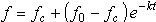
 ) from the equation to calculate rate:
 button located to the left of the field. This displays the